| Kepler Tramp 1999 (a)
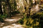
After a night in Te Anau, we got a bus to the start of the Kepler, at Dock Bay on Lake Te Anau. One crosses the Waiau River control gates along the lakeshore through some very pleasant native forest (NE19A). At Brod Bay, one starts a steady ascent to Mt Luxmore Hut.
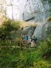
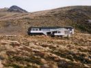
There is supposed to be a two hour climb to Limestone Bluffs (NE22A) (NE (lunch) and a further hour to the bushline, but being "broken in" by the Hollyford tramp, my companions (Ian Bardsley, John Barrell and Cathy Thompson) kept up a steady (?cracking) pace, so we were on the tops before we had time to get tired, and arrived at Luxmore Hut (NF7), and checked out the caves (NF8) before lunch.
The hut warden provided a worrying weather forecast predicting rain and 100km/hour winds the next day when we were going to be following exposed ridges. Even the DOC track guide warned against trying this section in bad weather. As we had come to see the views, and the day was still young, we decided to head on to Iris Burn Hut after lunch and take an extra day on Lake Manapouri. There are two emergency shelters on the way in case we had overestimated our abilities.
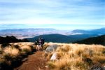
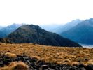
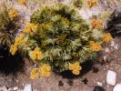
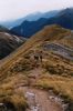
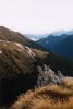
The walk along the ridges was pleasant, with good views (NF11,15) and the others felt fit enough to climb up the 70 odd metres to the top of Mt Luxmore on the way. I decided to take photos of the alpine plants (NF16), as we had seen plenty of panoramic views - but the real reason was to conserve my strength as we had already climbed 1200 metres and it was still a long way to Iris Burn. Check out NF11, NF15, NF16 and NF17 taken during my "rest".
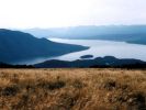
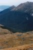
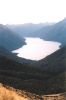
After the Luxmore Saddle, the track descends (NF18,20) to Forest Burn Shelter, gently ascends along a ridge to Hanging Valley Shelter, all with great views which were not enjoyed at leisure, given the need to get off the tops and on to Lake Manapouri before the weather closed in.
Continued on the
Next page
Return
To Tramping Index
for other tramping trips

|